Elliott Sainsbury, e.sainsbury@pgr.reading.ac.uk
To date, the 2020 North Atlantic hurricane season has been the most active on record, producing 20 named storms, 7 hurricanes, and a major hurricane which caused $9 billion in damages across the southern United States. With the potential for such destructive storms, it is understandable that a large amount of attention is paid to the North Atlantic basin at this time of year. Whilst hurricanes have been known to cause devastation in the tropics for centuries, until recently there was little appreciation for the destructive potential of these systems across Europe.
As tropical cyclones such as hurricanes move poleward – away from the tropics and into regions of lower sea surface temperatures and higher vertical wind shear, they undergo a process called extratropical transition (Klein et al., 2000): Over a period of time, the cyclones change from symmetric, warm cored systems into asymmetric cold core systems fuelled by horizontal temperature gradients, as opposed to latent heat fluxes (Evans et al., 2017). These systems, so-called post-tropical cyclones (PTCs), often reintensify in the mid-latitude Atlantic with consequences for land masses downstream – often Europe. This was highlighted in 2017, when ex-hurricane Ophelia impacted Ireland, bringing with it the strongest winds Ireland had seen in 50 years (Stewart, 2018). 3 people were killed, and 360,000 homes were without power.
In a recent paper, we quantify the risk associated with PTCs across Europe relative to mid-latitude cyclones (MLCs) for the first time – in terms of both the absolute risk (i.e. what fraction of high impact wind events across Europe are caused by PTCs?) and also the relative risk (for a given PTC, how likely is it to be associated with high-impact winds, and how does this compare to a given MLC?). By tracking all cyclones impacting a European domain (36-70N, 10W-30E) in the ERA5 reanalysis (1979-2017) using a feature tracking algorithm (Hodges, 1994, 1995, 1999), we identify the post-tropical cyclones using spatiotemporal matching (Hodges et al., 2017) with the observational record, IBTrACS (Knapp et al., 2010).

Figure 1 shows the distributions of maximum intensity for PTCs and MLCs across the entire European domain (top), Northern Europe (48-70°N, 10°W-30°E; middle) and Southern Europe (36-48°N, 10°W-30°E; bottom), using all cyclone tracks all year round. The distribution of PTC maximum intensities is higher (in terms of both wind speed and MSLP) than MLCs, particularly across Northern Europe. The difference between the maximum intensity distributions of PTCs and MLCs across Northern Europe is statistically significant (99%). PTCs are also present in the highest of intensity bins, indicating that the strongest PTCs have intensities comparable to strong wintertime MLCs.
Whilst Figure 1 shows that PTCs are stronger than MLCs even when considering MLCs forming all year round (including the often much stronger wintertime MLCs), it is also useful to compare the risks posed by PTCs relative to MLCs forming at the same time of the year – during the North Atlantic hurricane season (June 1st-November 30th).
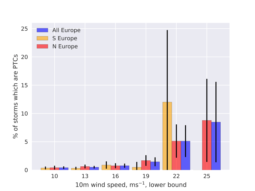
Figure 2 shows the fraction of all storms, binned by their maximum intensity in their respective domains, which are PTCs. For storms with weak-moderate maximum winds (first three bins in the figure), <1% of such events are caused by PTCs (with the remaining 99% caused by MLCs). For stronger storms, particularly those of storm force (>25 ms-1 on the Beaufort scale), this percentage is much higher. Despite less than 1% of all storms impacting Northern Europe during hurricane season being PTCs, almost 9% of all storms with storm-force winds which impact the region are PTCs, suggesting that a disproportionate fraction of high-impact windstorms are PTCs. 8.2% of all Northern Europe impacting PTCs which form during hurricane season impact the region with storm-force winds. This fraction is only 0.8% for MLCs, suggesting that the fraction of PTCs impacting Northern Europe with storm-force winds is approximately 10 times greater than MLCs.
Here we have shown that PTCs, at their maximum intensity over Northern Europe, are stronger than MLCs. However, the question still remains as to why this is the case. Warm-seclusion storms post-extratropical transition have been shown to have the fastest rates of reintensification (Kofron et al., 2010) and typically have the lowest pressures upon impacting Europe (Dekker et al., 2018). Given the climatological track that PTCs often take over the warm waters of the Gulf stream, along with the contribution of both baroclinic instability and latent heat release for warm-seclusion development (Baatsen et al., 2015), one hypothesis may be that PTCs are more likely to develop into warm seclusion storms than the broader class of mid-latitude cyclones, potentially explaining the disproportionate impacts they cause across Europe. This will be the topic of future work.
Despite PTCs disproportionately impacting Europe with high intensities, they are a relatively small component of the total cyclone risk in the current climate. However, only small changes are expected in MLC number and intensity under RCP 4.5 (Zappa et al., 2013). Conversely, the number of hurricane-force (>32.6 ms-1) storms impacting Norway, the North Sea and the Gulf of Biscay has been projected to increases by a factor of 6.5, virtually all of which originate in the tropics (Haarsma et al., 2013). Whilst the absolute contribution of PTCs to hurricane season windstorm risk is currently low, PTCs may make an increasingly significant contribution to European windstorm risk in a future climate.
Interested to read more? Read our paper, published in Geophysical Research Letters.
Sainsbury, E. M., R. K. H. Schiemann, K. I. Hodges, L. C. Shaffrey, A. J. Baker, K. T. Bhatia, 2020: How Important Are Post‐Tropical Cyclones for European Windstorm Risk? Geophysical Research Letters, 47(18), e2020GL089853, https://doi.org/10.1029/2020GL089853
References
Baatsen, M., Haarsma, R. J., Van Delden, A. J., & de Vries, H. (2015). Severe Autumn storms in future Western Europe with a warmer Atlantic Ocean. Climate Dynamics, 45, 949–964. https://doi.org/10.1007/s00382-014-2329-8
Dekker, M. M., Haarsma, R. J., Vries, H. de, Baatsen, M., & Delden, A. J. va. (2018). Characteristics and development of European cyclones with tropical origin in reanalysis data. Climate Dynamics, 50(1), 445–455. https://doi.org/10.1007/s00382-017-3619-8
Evans, C., Wood, K. M., Aberson, S. D., Archambault, H. M., Milrad, S. M., Bosart, L. F., et al. (2017). The extratropical transition of tropical cyclones. Part I: Cyclone evolution and direct impacts. Monthly Weather Review, 145(11), 4317–4344. https://doi.org/10.1175/MWR-D-17-0027.1
Haarsma, R. J., Hazeleger, W., Severijns, C., De Vries, H., Sterl, A., Bintanja, R., et al. (2013). More hurricanes to hit western Europe due to global warming. Geophysical Research Letters, 40(9), 1783–1788. https://doi.org/10.1002/grl.50360
Hodges, K., Cobb, A., & Vidale, P. L. (2017). How well are tropical cyclones represented in reanalysis datasets? Journal of Climate, 30(14), 5243–5264. https://doi.org/10.1175/JCLI-D-16-0557.1
Hodges, K. I. (1994). A general method for tracking analysis and its application to meteorological data. Monthly Weather Review, 122(11), 2573–2586. https://doi.org/10.1175/1520-0493(1994)122<2573:AGMFTA>2.0.CO;2
Hodges, K. I. (1995). Feature Tracking on the Unit Sphere. Monthly Weather Review, 123(12), 3458–3465. https://doi.org/10.1175/1520-0493(1995)123<3458:ftotus>2.0.co;2
Hodges, K. I. (1999). Adaptive constraints for feature tracking. Monthly Weather Review, 127(6), 1362–1373. https://doi.org/10.1175/1520-0493(1999)127<1362:acfft>2.0.co;2
Klein, P. M., Harr, P. A., & Elsberry, R. L. (2000). Extratropical transition of western North Pacific tropical cyclones: An overview and conceptual model of the transformation stage. Weather and Forecasting, 15(4), 373–395. https://doi.org/10.1175/1520-0434(2000)015<0373:ETOWNP>2.0.CO;2
Knapp, K. R., Kruk, M. C., Levinson, D. H., Diamond, H. J., & Neumann, C. J. (2010). The international best track archive for climate stewardship (IBTrACS). Bulletin of the American Meteorological Society, 91(3), 363–376. https://doi.org/10.1175/2009BAMS2755.1
Kofron, D. E., Ritchie, E. A., & Tyo, J. S. (2010). Determination of a consistent time for the extratropical transition of tropical cyclones. Part I: Examination of existing methods for finding “ET Time.” Monthly Weather Review, 138(12), 4328–4343. https://doi.org/10.1175/2010MWR3180.1
Stewart, S. R. (2018). Tropical Cyclone Report: Hurricane Ophelia. National Hurricane Center, (February), 1–32. https://doi.org/AL142016
Zappa, G., Shaffrey, L. C., Hodges, K. I., Sansom, P. G., & Stephenson, D. B. (2013). A multimodel assessment of future projections of North Atlantic and European extratropical cyclones in the CMIP5 climate models. Journal of Climate, 26(16), 5846–5862. https://doi.org/10.1175/JCLI-D-12-00573.1
