Helicopter Underwater Escape Training for Arctic Field Campaign

Hannah Croad h.croad@pgr.reading.ac.uk

The focus of my PhD project is investigating the physical mechanisms behind the growth and evolution of summer-time Arctic cyclones, including the interaction between cyclones and sea ice. The rapid decline of Arctic sea ice extent is allowing human activity (e.g. shipping) to expand into the summer-time Arctic, where it will be exposed to the risks of Arctic weather. Arctic cyclones produce some of the most impactful Arctic weather, associated with strong winds and atmospheric forcings that have large impacts on the sea ice. Hence, there is a demand for improved forecasts, which can be achieved through a better understanding of Arctic cyclone mechanisms. 

My PhD project is closely linked with a NERC project (Arctic Summer-time Cyclones: Dynamics and Sea-ice Interaction), with an associated field campaign. Whereas my PhD project is focused on Arctic cyclone mechanisms, the primary aims of the NERC project are to understand the influence of sea ice conditions on summer-time Arctic cyclone development, and the interaction of cyclones with the summer-time Arctic environment. The field campaign, originally planned for August 2021 based in Svalbard in the Norwegian Arctic, has now been postponed to August 2022 (due to ongoing restrictions on international travel and associated risks for research operations due to the evolving Covid pandemic). The field campaign will use the British Antarctic Survey’s low-flying Twin Otter aircraft, equipped with infrared and lidar instruments, to take measurements of near-surface fluxes of momentum, heat and moisture associated with cyclones over sea ice and the neighbouring ocean. These simultaneous observations of turbulent fluxes in the atmospheric boundary layer and sea ice characteristics, in the vicinity of Arctic cyclones, are needed to improve the representation of turbulent exchange over sea ice in numerical weather prediction models. 

Those wishing to fly onboard the Twin Otter research aircraft are required to do Helicopter Underwater Escape Training (HUET). Most of the participants on the course travel to and from offshore facilities, as the course is compulsory for all passengers on the helicopters to rigs. In the unlikely event that a helicopter must ditch on the ocean, although the aircraft has buoyancy aids, capsize is likely because the engine and rotors make the aircraft top heavy. I was apprehensive about doing the training, as having to escape from a submerged aircraft is not exactly my idea of fun. However, I realise that being able to fly on the research aircraft in the Arctic is a unique opportunity, so I was willing to take on the challenge! 

The HUET course is provided by the Petans training facility in Norwich. John Methven, Ben Harvey, and I drove to Norwich the night before, in preparation for an early start the next day. We spent the morning in the classroom, covering helicopter escape procedures and what we should expect for the practical session in the afternoon. We would have to escape from a simulator recreating a crash landing on water. The simulator replicates a helicopter fuselage, with seats and windows, attached to the end of a mechanical arm for controlled submersion and rotation. The procedure is (i) prepare for emergency landing: check seatbelt is pulled tight, headgear is on, and that all loose objects are tucked away, (ii) assume the brace position on impact, and (iii) keep one hand on the window exit and the other on your seatbelt buckle. Once submerged, undo your seatbelt and escape through the window. After a nervy lunch, it was time to put this into practice. 

The aircraft simulator being submerged in the pool (Source: Petans promotional video

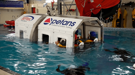
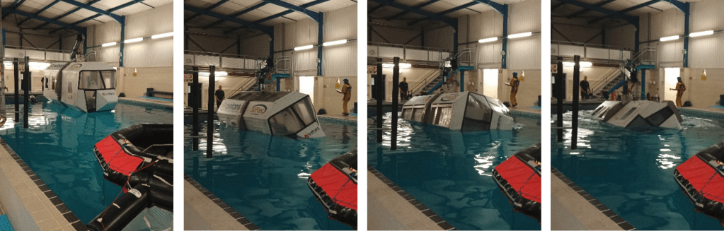
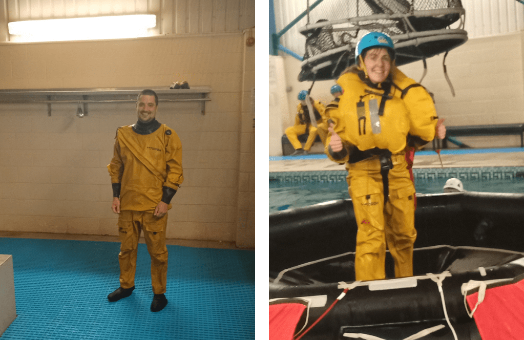
The practical part of the course took place in a pool (the temperature resembled lukewarm bath water, much warmer than the North Atlantic!). We were kitted up with two sets of overalls over our swimming costumes, shoes, helmets, and jackets containing a buoyancy aid. We then began the training in the aircraft simulator. Climb into the aircraft and strap yourself into a seat. The seatbelt had to be pulled tight, and was released by rotating the central buckle. On the pilots command, prepare for emergency landing. Assume the brace position, and the aircraft drops into the water. Hold on to the window and your seatbelt buckle, and as the water reaches your chest, take a deep breath. Wait for the cabin to completely fill with water and stop moving – only then undo your seatbelt and get out! 

The practical session consisted of three parts. In the first exercise, the aircraft was submerged, and you had to escape through the window. The second exercise was similar, except that panes were fitted on the windows, which you had to push out before escaping. In the final exercise, the aircraft was submerged and rotated 180 degrees, so you ended up upside down (and with plenty of water up your nose), which was very disorientating! Each exercise required you to hold your breath for roughly 10 seconds at a time. Once we had escaped and reached the surface, we deployed our buoyancy aids, and climbed to safety onto the life raft. 

Going for a spin! The aircraft simulator being rotated with me strapped in
Ben and I happy to have survived the training!

The experience was nerve-wracking, and really forced me to push myself out of my comfort zone. I didn’t need to be too worried though, even after struggling with undoing the seatbelt a couple of times, I was assisted by the diving team and encouraged to go again. I was glad to get through the exercises, and pass the course along with the others. This was an amazing experience (definitely not something I expected to do when applying for a PhD!), and I’m now looking forward to the field campaign next year. 

Organising a virtual conference

Gwyneth Matthews – g.r.matthews@pgr.reading.ac.uk

A Doctoral Training Programme (DTP) provides funding, training, and opportunities for many PhD students in our department. Every year three environmentally focused DTPs: the SCENARIO NERC DTP, the London NERC DTP, and the Science and Solutions for a Changing Planet (SSCP) DTP, combine forces to hold a conference bringing together hundreds of PhD students to present their work and to network. As for many conferences in 2020, COVID19 disrupted our plans for the Joint DTP conference.  Usually the conference is hosted at one of the universities involved with a DTP however, this year it was held virtually using a mixture of Zoom and Slack. 

The decision to go virtual was difficult. We had to decide early in the pandemic when we didn’t know how long the lockdown would last nor what restrictions would be in place in September. If possible, we wanted to keep the conference in-person so that attendees got the full experience as it’s often the first time the new cohort meet and one of the few chances for the DTPs to mingle. However, as meeting and mingling was, and is, very much discouraged, making the decision to go virtual early on meant we had time to re-organise.  

Figure 1 – It was initially planned to hold the conference at the University of Surrey campus, which is located in Guildford, Surrey and hosts some students from the SCENARIO NERC DTP. The conference was instead held on Slack, an online communication platform that allows content to be divided into channels, and presentation sessions were hosted on Zoom.

When we thought we were organising a conference to be held at the University of Surrey, the main theme was “Engaging Sustainability” with the aim of making the conference as sustainable as possible. Since one of the often-made criticisms of conferences, especially those within the environmental fields, is the impact of large numbers of people travelling to one place, a virtual conference has obvious environmental benefits. An additional benefit was that we could invite guest speakers, such as Mya-Rose Craig (aka Bird Girl @birdgirluk), who may not have been able to attend if the event was held in person. It was also easier for some participants who had other commitments, such as childcare, to attend, although poor internet connection was an issue for others. 

The pandemic exposed, and often enhanced, many issues within academia and society in general. A questionnaire sent out before the event showed that most attendees were finding working from home and all other pandemic induced changes exhausting and mentally challenging. The recent Black Lives Matter protests around the world and the disproportionate impact of COVID on ethnic minority communities highlighted both the overt and systemic racism that is still prevalent in society. The UK Research and Innovation COVID funding controversy, and an increased focus on the challenges faced by the LGBTQ+ researchers emphasised the inequalities and poor representation specifically experienced in academia. Scientists working at the forefront of the pandemic response faced the challenge of providing clear information to enable people and policy makers to take life-disrupting actions before they are directly impacted; a challenge familiar to climate and environmental scientists. These issues gave us our topics for the external sessions which focused on wellbeing, inclusivity and diversity in academia, and communicating research.  

Barring technical difficulties, oral presentations are easy to replicate online, however, virtual conferences held earlier this year often had issues with recreating the poster sessions. Attempting to learn from these snags, instead of replicating an in-person poster session and possibly producing a poor-quality knock-off, participants were asked to create an animated “Twitter poster”. These were required to describe the key points of their research in a simple format that could be shared on social media and that was accessible to a non-expert. The posters were available for comments and questions throughout the two days in one easy-to-find location. Many of the participants shared their posters on Twitter after the conference using the conference hashtag #JointDTPCon.  

Another issue we faced was how to run a social and networking event. We kept the social event simple. A quiz. A pandemic classic with a fantastic double act as hosts. Randomly assigned teams meant that new connections could be made. However, the quiz was held online and after a full day of video calls most people didn’t want to spend their evenings also starring at a screen.  

Fig 2 – Jo Herschan and Lucinda King, members of the SCENARIO DTP and on the conference organising committee, hosted an entertaining quiz on the first night of the conference. An ethical objects photo round linked the quiz to the conference’s main theme.

With everyone having stayed at home and everything being conducted virtually for a few months by the time of our conference, Zoom fatigue was an issue we were aware could occur and tried to counter as much as possible during the day without losing any of the exciting new research being presented. In the weeks running up to the conference we had several discussions about how to encourage people to move throughout the two days without missing any of the sessions they wanted to attend. We decided on two ideas: a yoga session and a walking challenge. The yoga session was a success and not only gave participants an opportunity to stretch in the middle of the day but also linked strongly to our theme of researcher wellbeing. The walking challenge was not as successful. The aim was that collectively the conference participants would walk the distance from Land’s End to John O’Groats. We did not make it that far; but we did make it out of Cornwall. 

Fig 3 – Using World Walking to track the distance, we intended to collectively walk the 1576km (or 2,299,172 steps) from Land’s End to John O’Groats. This may have been an optimistic endeavour as we only achieved 235km (343, 311 steps).  

Helping to organise a virtual conference as part of an enthusiastic committee was a lot of fun and attending the conference and learning about the research being undertaken (from fungi in Kew Gardens to tigers in North Korea) was even more fun. There is still enormous room for improvement in virtual conferences, but since they aren’t as well established as traditional in-person conferences there’s also a lot of flexibility for each conference to be designed differently. Once we’re through the pandemic and in-person conferences return it’d be nice for some of these benefits to be maintained as hybrid conferences are designed.   

Oceans in Weather and Climate Course 2018

email: r.frew@pgr.reading.ac.uk

Between the 11th-16th March myself and four other PhDs and post docs attended the Ocean in Weather and Climate (OiWC) course at the Met Office, Exeter. This NERC advanced training course was aimed at PhDs, postdocs and beyond. It provided a great opportunity to spend a week meeting other Oceanography researchers at varying stages of their career, and to expand your understanding of the oceans role in climate beyond the scope of your own work.

The week kicked off with an ice breaker where we had do some ‘Scientific speed dating’, chatting to other participants about: Where are you from? What do you work on? What is your main hobby? What is the biggest question in your field of research? This set the tone for a very interactive week full of interesting discussions between all attendees and speakers alike. Course participants were accommodated at The Globe Inn situated in Topsham, a cute village-sized town full of pastel-coloured houses, cosy pubs, art galleries, and beautiful riverside walks to stretch your legs in the evenings.

The days consisted of four 1.5 hour sessions, split up by caffeine and biscuit breaks to recharge before the next session.

Topics covered in the lecture-style talks included…

  • Dynamical Theory
  • Modelling the Ocean
  • Observations
  • Ocean-atmosphere coupling
  • Air-sea fluxes
  • High Resolution Ocean modelling in coupled forecast systems
  • The Meridional Overturning Circulation
  • The Southern Ocean in climate and climatic change
  • Climate variability on diurnal, seasonal, annual, inter-annual, decadal timescales
  • Climate extremes
  • Climate sensitivity, heat uptake and sea level.

OceanResolutionFigure
A recurring figure of the week…. taken from Helene Hewitt’s talk on high resolution ocean modelling showing ocean surface currents from HadGEM3-based global coupled models at different resolutions (eddy resolving, eddy permitting and eddy parameterised).


All the talks were very interesting and were followed by some stimulating discussion. Each session provided an overview of each topic and an indication of the current research questions in each area at the moment.

In the post lunch session, there were group practical sessions. These explored observational ARGO float data and model output. The practicals, written in iPython notebooks, were designed to let us play with some data, giving us a series of questions to trigger group discussions to deepen understanding of topics covered that morning.

The course also included some ‘softer’ evening talks, giving research career advice in a more informal manner. Most evenings were spent exploring the lovely riverside walks and restaurants/pubs of Topsham. The final evening was spent all together at the Cosy Club in Exeter, rounding off a very interesting and enjoyable week!

VMSG and COMET 2018 (or a Tale of Two Conferences)

The Volcanic and Magmatic Studies Group (VMSG) held a conference from the 3-6th of January in Leeds. The Centre for Observation and Modelling of Earthquakes, Volcanoes and Tectonics (COMET) held a student conference from 8-9th January in Cambridge. It was a conference double-whammy about all things volcanic – heaven!

VMSG is a joint special interest group of the Mineralogical Society of Great Britain and Ireland and the Geological Society of London. The VMSG conference is a fairly small affair, with about 200 in attendance, and it brings together research in geochemistry, seismology, volcanology and related fields. Because of its size, it’s a nice informal space where there is a focus on students presenting their work to the VMSG community, but anyone is free to present their research.

Talks ranged from how tiny fossils, called diatoms, became trapped in a pyroclastic density current, to modelling of lava domes, to how local people interact with the volcano they live on at Masaya, to every aspect of volcanology you can think of. The final talk was definitely a highlight – with everyone in 3D glasses to look at volcanic plumes across Russia, it really brought the satellite images to life (and we got to keep the glasses).

90 posters on a variety of topics were presented, the majority of which were by students (I was one of them). There was of course an obligatory dinner and disco to round off the second day of talks, and a great chance to network with other people from VMSG.

For the best poster title of the conference, you need look no further than this gem.

The conference also provides workshops on different aspects of research, with sessions on writing papers, diffusion modelling and InSAR to name a few. These were hosted on the 6th at the University of Leeds Environment and Earth Sciences Department, and comprised a full day of talks and labs so you could get to grips with the techniques you were being shown. I attended the InSAR workshop, which gave a good introduction to the topic of comparing two satellite images and seeing where the ground had moved. There was also a session on deformation modelling in the afternoon and playing with bits of code.

26771981_1615887968434336_143604950_o
An afternoon of modelling InSAR deformations and code – hill-arity ensued.

Then it was onto the second leg of the conferences, which took the action to Cambridge, where students that are part of COMET met up to discuss work and attend talks from 8-9th January.

26732711_1615887681767698_951066323_o
Gneiss weather in Cambridge!

COMET is a National Environment Research Council Centre of Excellence, it comprises a group of researchers that uses remote and ground sensed data and models to study earthquakes and volcanoes. They also work with the British Geological Survey and the European Space Agency, and fund PhD projects in related fields.

The meet-up of students comprised two days of talks from students, with some keynote speakers who had been past members of COMET that had gone on to careers outside of academia. The talks from second and third years included: remote sensing and InSAR being used to examine tectonic strain in the East African Rift Valley and slip (movement) rates along faults in Tibet, modelling how gas bubbles in magma change the more crystals you add to the magma, and using cosmogenic isotopes to work out slip rates on a fault in Italy.

26695576_1615887065101093_724648553_o
The Department had cabinets and cabinets of samples that rocked.

First years are also given the chance to give a talk lasting 5 minutes, so I filled people in on what I’d been up to in the past four months – lots of data collection! My project will be using satellite data to look at the varied eruption behaviour of Bagana volcano in Papua New Guinea, with a view to modelling this behaviour to better understand what causes it. Bagana has a tendency to send out thick lava flows in long pulses and let out lots of gas, and occasionally then violently erupt and let out lots of ash and hot pyroclastic density currents. But it is very understudied, as it is so remote – so there’s lots still to be learnt about it!

26736005_1616717381684728_2011570642_o
Me with my poster (I’ve run out of geology puns).

The meet-up also included a fancy meal in Pembroke College’s Old Library, with candles and it felt a bit like being at Hogwarts! Then it was back to Reading, thoroughly worn out, but with lots of ideas and many useful contacts – VMSG2019 is in St. Andrews and I can’t wait.

New Forecast Model Provides First Global Scale Seasonal River Flow Forecasts

new_web_figure2_rivernetwork

Over the past ~decade, extended-range forecasts of river flow have begun to emerge around the globe, combining meteorological forecasts with hydrological models to provide seasonal hydro-meteorological outlooks. Seasonal forecasts of river flow could be useful in providing early indications of potential floods and droughts; information that could be of benefit for disaster risk reduction, resilience and humanitarian aid, alongside applications in agriculture and water resource management.

While seasonal river flow forecasting systems exist for some regions around the world, such as the U.S., Australia, Africa and Europe, the forecasts are not always accessible, and forecasts in other regions and at the global scale are few and far between.  In order to gain a global overview of the upcoming hydrological situation, other information tends to be used – for example historical probabilities based on past conditions, or seasonal forecasts of precipitation. However, precipitation forecasts may not be the best indicator of floodiness, as the link between precipitation and floodiness is non-linear. A recent paper by Coughlan-de-Perez et al (2017), “should seasonal rainfall forecasts be used for flood preparedness?”, states:

“Ultimately, the most informative forecasts of flood hazard at the seasonal scale are streamflow forecasts using hydrological models calibrated for individual river basins. While this is more computationally and resource intensive, better forecasts of seasonal flood risk could be of immense use to the disaster preparedness community.”

twitter_screenshotOver the past months, researchers in the Water@Reading* research group have been working with the European Centre for Medium-Range Weather Forecasts (ECMWF), to set up a new global scale hydro-meteorological seasonal forecasting system. Last week, on 10th November 2017, the new forecasting system was officially launched as an addition to the Global Flood Awareness System (GloFAS). GloFAS is co-developed by ECMWF and the European Commission’s Joint Research Centre (JRC), as part of the Copernicus Emergency Management Services, and provides flood forecasts for the entire globe up to 30 days in advance. Now, GloFAS also provides seasonal river flow outlooks for the global river network, out to 4 months ahead – meaning that for the first time, operational seasonal river flow forecasts exist at the global scale – providing globally consistent forecasts, and forecasts for countries and regions where no other forecasts are available.

The new seasonal outlook is produced by forcing the Lisflood hydrological river routing model with surface and sub-surface runoff from SEAS5, the latest version of ECMWF’s seasonal forecasting system, (also launched last week), which consists of 51 ensemble members at ~35km horizontal resolution. Lisflood simulates the groundwater and routing processes, producing a probabilistic forecast of river flow at 0.1o horizontal resolution (~10km, the resolution of Lisflood) out to four months, initialised using the latest ERA-5 model reanalysis.

The seasonal outlook is displayed as three new layers in the GloFAS web interface, which is publicly (and freely) available at www.globalfloods.eu. The first of these gives a global overview of the maximum probability of unusually high or low river flow (defined as flow exceeding the 80th or falling below the 20th percentile of the model climatology), during the 4-month forecast horizon, in each of the 306 major world river basins used in GloFAS-Seasonal.

new_web_figure1_basins
The new GloFAS Seasonal Outlook Basin Overview and River Network Layers.

The second layer provides further sub-basin-scale detail, by displaying the global river network (all pixels with an upstream area >1500km2), again coloured according to the maximum probability of unusually high or low river flow during the 4-month forecast horizon. In the third layer, reporting points with global coverage are displayed, where more forecast information is available. At these points, an ensemble hydrograph is provided showing the 4-month forecast of river flow, with thresholds for comparison of the forecast to typical or extreme conditions based on the model climatology. Also displayed is a persistence diagram showing the weekly probability of exceedance for the current and previous three forecasts.

blog_screenshot
The new GloFAS Seasonal Outlook showing the river network and reporting points providing hydrographs and persistence diagrams.

Over the coming months, an evaluation of the system will be completed – for now, users are advised to evaluate the forecasts for their particular application. We welcome any feedback on the forecast visualisations and skill – feel free to contact me at the email address below!

To find out more, you can see the University’s press release here, further information on SEAS5 here, and the user information on the seasonal outlook GloFAS layers here.

*Water@Reading is “a vibrant cross-faculty centre of research excellence at the University of Reading, delivering world class knowledge in water science, policy and societal impacts for the UK and internationally.”

Full list of collaborators: 

Rebecca Emerton1,2, Ervin Zsoter1,2, Louise Arnal1,2, Prof. Hannah Cloke1, Dr. Liz Stephens1, Dr. Florian Pappenberger2, Prof. Christel Prudhomme2, Dr Peter Salamon3, Davide Muraro3, Gabriele Mantovani3

1 University of Reading
2 ECMWF
3 European Commission JRC

Contact: r.e.emerton@pgr.reading.ac.uk

The 2017 SCENARIO Conference: Frontiers in Natural Environment Research

Every year students from the SCENARIO (Science of the Environment, Natural and Anthropogenic Processes, Impacts and Opportunities) Doctoral Training Partnership organise an annual conference. Those invited include SCENARIO students, NERC employees and industrial partners. This year, after last year’s successful collaboration with the University of Oklahoma, it was decided that we would run the conference (Frontiers in Natural Environment Research) with the Science and Solutions for a Changing Planet (SSCP) and London NERC DTPs, led by a variety of universities and institutions in London.

A similar conference was organised last year (Perspectives on Environmental Change) between SSCP and the London NERC DTP, which was a rousing success. This year, with the addition of Reading and Surrey, we had almost 200 delegates attending with a healthy proportion of supervisors and industry partners, with over 40 oral presentations and 40 posters from students at the various institutions. The conference was held in the Physics building at Imperial College, a literal stone’s throw away from the Royal Albert Hall.

Organising the conference was a daunting task; there was a lot of work involved between the nine PhD students on the committee! One of the challenges, (but also one of the most exciting parts of the conference), was the sheer variety of research being presented. Many of the attendees were from the Met department, but there were also students from Chemistry and Geography from SCENARIO, and students from the London institutions doing topics as varied as sociology, ecology, biology, materials science and plate tectonics. This made for a really interesting conference since there was so much on offer from such a wide range of fields, but made our lives quite difficult when trying to organise keynote speakers and sort abstracts!

IMG_8983

As well as the student presentations we also ran workshops and panel discussions, and had two invited keynote speakers. The workshops were about communicating science through social media, and also on getting published in one of the Nature journals (similar to the successful workshop ran by SCENARIO here at Reading). The panel discussions were themed around “Science and Development” and “Science in a post-truth world”, looking at ways in which science (particularly that within the NERC remit) can help to solve the UN’s Sustainable Development Goals, and how we communicate science in a time of “fake news”.

IMG_8990

Perhaps my favourite part of the conference were the two keynote speakers. Finding speakers who would appeal to the majority of people attending the conference was no easy task, given the huge range of disciplines!

Opening the conference, Marcus Munafo, Professor in Biological Psychology at Bristol University spoke about the “reproducibility crisis” and how incentive structures affect the scientific process. I can honestly say it was one of the most thought-provoking lectures I’ve ever been to. His main argument was that ultimately science is done by people who have an incentive to do certain things, (e.g. publish in high impact journals), for the benefit of their careers. However, this incentivisation means that often one “big result” can mean more for the career of someone than all the work they’ve done previously, even if that result ended up being retracted or proven false later on, (he went on to demonstrate that happens a lot). One of the statistics he presented was that the higher the impact factor of a journal, the higher the chance of retraction, which I thought was really interesting and certainly made me re-evaluate the way in which I approach my own work.

The other keynote speaker was Lucy Hawkes, Senior Lecturer in Physiological Ecology at Exeter, talking about her work and career, particularly “biologging” of animals and looking at their migratory patterns. Aside from all the great anecdotes and stories (like swimming with sharks in order to plant bio-tags on them), from a meteorologist’s perspective it was interesting listening to her talk about how these migratory patterns change with the climate.

Of course any conference worth its salt has entertainment and things outside work. A BBQ was hosted in the courtyard underneath the Queen’s Tower, and drinks and comedy (the Science Showoff) in the wonderfully titled hBar at Imperial. The Science Showoff in particular was really good, hosted by a professional comedian but with most of the material coming from PhD students at the various institutes (although shamefully no-one from Met volunteered).

IMG_9012

One of the other really useful parts was meeting students from disparate fields at the other institutions. As Joanna Haigh (director of the SSCP DTP) said in her closing speech, the people we meet at these conferences will be our colleagues for our entire careers, so it’s really important to get to know people socially and professionally. In the end I think it went really well, and I’m certainly looking forward to seeing the London students again at next year’s conference!

Should we be ‘Leaf’-ing out vegetation when parameterising the aerodynamic properties of urban areas?

Email: C.W.Kent@pgr.reading.ac.uk

When modelling urban areas, vegetation is often ignored in attempt to simplify an already complex problem. However, vegetation is present in all urban environments and it is not going anywhere… For reasons ranging from sustainability to improvements in human well-being, green spaces are increasingly becoming part of urban planning agendas. Incorporating vegetation is therefore a key part of modelling urban climates. Vegetation provides numerous (dis)services in the urban environment, each of which requires individual attention (Salmond et al. 2016). However, one of my research interests is how vegetation influences the aerodynamic properties of urban areas.

Two aerodynamic parameters can be used to represent the aerodynamic properties of a surface: the zero-plane displacement (zd) and aerodynamic roughness length (z0). The zero-plane displacement is the vertical displacement of the wind-speed profile due to the presence of surface roughness elements. The aerodynamic roughness length is a length scale which describes the magnitude of surface roughness. Together they help define the shape and form of the wind-speed profile which is expected above a surface (Fig. 1).

blogpostpic

Figure 1: Representation of the wind-speed profile above a group of roughness elements. The black dots represent an idealised logarithmic wind-speed profile which is determined using the zero-plane displacement (zd) and aerodynamic roughness length (z0) (lines) of the surface.

For an urban site, zd and z0 may be determined using three categories of methods: reference-based, morphometric and anemometric. Reference-based methods require a comparison of the site to previously published pictures or look up tables (e.g. Grimmond and Oke 1999); morphometric methods describe zd and z0 as a function of roughness-element geometry; and, anemometric methods use in-situ observations. The aerodynamic parameters of a site may vary considerably depending upon which of these methods are used, but efforts are being made to understand which parameters are most appropriate to use for accurate wind-speed estimations (Kent et al. 2017a).

Within the morphometric category (i.e. using roughness-element geometry) sophisticated methods have been developed for buildings or vegetation only. However, until recently no method existed to describe the effects of both buildings and vegetation in combination. A recent development overcomes this, whereby the heights of all roughness elements are considered alongside a porosity correction for vegetation (Kent et al. 2017b). Specifically, the porosity correction is applied to the space occupied and drag exerted by vegetation.

The development is assessed across several areas typical of a European city, ranging from a densely-built city centre to an urban park. The results demonstrate that where buildings are the dominant roughness elements (i.e. taller and occupying more space), vegetation does not obviously influence the calculated geometry of the surface, nor the aerodynamic parameters and the estimated wind speed. However, as vegetation begins to occupy a greater amount of space and becomes as tall as (or larger) than buildings, the influence of vegetation is obvious. Expectedly, the implications are greatest in an urban park, where overlooking vegetation means that wind speeds may be slowed by up to a factor of three.

Up to now, experiments such as those in the wind tunnel focus upon buildings or trees in isolation. Certainly, future experiments which consider both buildings and vegetation will be valuable to continue to understand the interaction within and between these roughness elements, in addition to assessing the parameterisation.

References

Grimmond CSB, Oke TR (1999) Aerodynamic properties of urban areas derived from analysis of surface form. J Appl Meteorol and Clim 38:1262-1292.

Kent CW, Grimmond CSB, Barlow J, Gatey D, Kotthaus S, Lindberg F, Halios CH (2017a) Evaluation of Urban Local-Scale Aerodynamic Parameters: Implications for the Vertical Profile of Wind Speed and for Source Areas. Boundary-Layer Meteorology 164: 183-213.

Kent CW, Grimmond CSB, Gatey D (2017b) Aerodynamic roughness parameters in cities: Inclusion of vegetation. Journal of Wind Engineering and Industrial Aerodynamics 169: 168-176.

Salmond JA, Tadaki M, Vardoulakis S, Arbuthnott K, Coutts A, Demuzere M, Dirks KN, Heaviside C, Lim S, Macintyre H (2016) Health and climate related ecosystem services provided by street trees in the urban environment. Environ Health 15:95.

The onset and end of wet seasons over Africa

Email: c.m.dunning@pgr.reading.ac.uk

For many Africans, the timing of the wet season is of crucial importance, especially for those reliant upon subsistence agriculture, who depend on the seasonal rains for crop irrigation. In addition, the wet season recharges lakes, rivers and water storage tanks which constitute the domestic water supply in some areas. The timing of the wet season also affects the availability of energy from hydroelectric schemes, and has impacts upon the prevalence of certain disease carrying vectors, such as mosquitoes.

Climate change is already threatening many vulnerable populations, and changes in the timing or intensity of the wet season, or increasing uncertainty in the timing of the onset, may lead to significant socio-economic impacts. But before we consider future projections or past changes in the seasonality, we need to go back a few steps.

The first step is to find a method for determining when the wet season starts and ends (its ‘onset’ and ‘cessation’). In order to look at large-scale shifts in the timing of the wet season and relate this to wider-scale drivers, this method needs to be applicable across the entirety of continental Africa. Most previous methods for determining the onset focus on the national to regional scale, and are dependent on the exceedance of a certain threshold e.g. the first week with at least 20mm of rainfall, with one rainfall event of more than 10mm, and no dry spell of more than 10 days after the rain event for the next month. While such definitions work well at a national scale they are not applicable at a continental scale where rainfall amounts vary substantially. A threshold suitable for the dry countries at the fringes of the Sahara would not be suitable in the wetter East African highlands.

In addition to a vast range of rainfall amounts, the African continent also spans multiple climatic regimes. The seasonal cycle of precipitation over continental Africa is largely driven by the seasonal progression of the ITCZ and associated rain belts, which follows the maximum incoming solar radiation. In the boreal summer, when the thermal equator sits between the equator and the Tropic of Cancer, the ITCZ sits north of the equator and West Africa and the Sahel experience a wet season. During the boreal autumn the ITCZ moves south, and southern Africa experiences a wet season during the austral summer, followed by the northward return of the ITCZ during the boreal spring. As a consequence of this, central African regions and the Horn of Africa experience two wet seasons per year – one as the ITCZ travels north, and a second as the ITCZ travels south. A method for determining the onset and cessation at the continental scale thus needs to account for regions with multiple wet seasons per year.

In our paper (available here) we propose such a method, based on the method of Liebmann et al (2012). The method has three steps:

  • Firstly, determine the number of seasons experienced per year at the location (or grid point) of interest. This is achieved using harmonic analysis – the amplitude of the first and second harmonic were computed, using the entire timeseries and their ratio compared. If the ratio was greater than 1.0, i.e. the amplitude of the second harmonic was greater than the amplitude of the first harmonic then the grid point was defined as having two wet seasons per year (biannual), if the ratio was less than one then it was defined as having an annual regime. Figure 1 shows the ratio for one African rainfall dataset (TARCATv2). Three regions are identified as biannual regions; the Horn of Africa, an equatorial strip extending from Gabon to Uganda and a small region on the southern West African coastline.

    blog_fig1
    Figure 1: Location of regions with one and two seasons per year, determined using harmonic analysis. Yellow indicates two seasons per year, while pink/purple indicates one season per year. Computed from TARCATv2 data.
  • Secondly the period of the year when the wet season occurs was determined. This was achieved by looking for minima and maxima in the climatological cumulative daily rainfall anomaly to identify one or two seasons.
  • The third and final stage is to calculate the onset and cessation dates for each year. This is done by looking for the minima and maxima in the cumulative daily rainfall anomaly, calculated for each season.

Figure 2 shows the seasonal progression of the onset and cessation, with the patterns observed in agreement with those expected from the driving physical mechanisms, and continuous progression across the annual/biannual boundaries. Over West Africa and the Sahel, Figure 2a-b shows zonally-contiguous progression patterns with onset following the onset of the long rains and moving north, and cessation moving southward, preceding the end of the short rains. Over southern Africa Figure 2c-d shows the onset over southern Africa starting in the north-west and south-east, following the onset of the short rains, reaching the East African coast last, and cessation starting at the Zimbabwe, Mozambique, South Africa border and spreading out radially into the cessation of the long rains.

As well as testing the method for compatibility with known physical drivers of African rainfall, agreement across multiple satellite-based rainfall estimates was also examined. In general, good agreement was found across the datasets, particularly for regions with an annual regime and over the biannual region of East Africa.

blog_fig2
Figure 2: Southward and northward progression of the onset and cessation across the annual/biannual boundaries, computed using GPCP daily rainfall data 1998-2013.

The advantage of having a method that works at the continental scale is the ability to look at the impact of large-scale oscillations on wider-scale variability. One application of this method was to investigate the impact of El Niño upon both the annual rains and short rains (Figure 3). In Figure 3 we see the well-documented dipole in rainfall anomaly, with higher rainfall totals over 0–15°S and the Horn of Africa in El Niño years and the opposite between 15°S and 30°S.  This anomaly is stronger when we use this method compared with using standard meteorological seasons. We can also see that while the lower rainfall to the south is colocated with later onset dates and a consequentially shorter season, the higher rainfall over the Horn of Africa is associated with later cessation of the short rains, with only small differences in onset date.

blog_fig3
Figure 3: a-c) Composite of onset, cessation and wet season rainfall in El Niño years for annual rains and short rains, minus the mean over 1982-2013, computed using CHIRPS data d) Oct-Feb rainfall anomaly in  years (CHIRPS).

In addition to using this method for research purposes, its application within an operational setting is also being explored. Hopefully, the method will be included within the Rainwatch platform, which will be able to provide users with a probabilistic estimate of whether or not the season has started, based on the rainfall experienced so far that year, and historical rainfall data.

For more details, please see the paper detailing this work:

Dunning, C.M., E Black, and R.P. Allan (2016) The onset and cessation of seasonal rainfall over Africa, Journal of Geophysical Research: Atmospheres, 121 11,405-11,424, doi: 10.1002/2016JD025428

References:

Liebmann, B., I. Bladé, G. N. Kiladis, L. M. Carvalho, G. B. Senay, D. Allured, S. Leroux, and C. Funk (2012), Seasonality of African precipitation from 1996 to 2009, J. Clim.25(12), 4304–4322.