Email: d.l.a.flack@pgr.reading.ac.uk
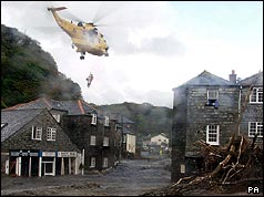
Showers are one of the many examples of convective events experienced in the UK, other such events include thunderstorms, supercells and squall lines. These type of events form most often in the summer but can also form over the sea in the winter. They form because the atmosphere is unstable, i.e. warm air over a cooler surface, this results in the creation of thermals. If there is enough water vapour in the air and the thermal reaches high enough the water vapour will condense and eventually form a convective cloud. Convective events produce intense, often very localised, rainfall, which can result in flash floods, e.g. Boscastle 2004.
Flash floods are very difficult to predict, unlike flood events that happen from the autumnal and winter storms e.g. floods from Storms Desmond and Frank last winter, and the current floods (20-22 November). So often there is limited lead time for emergency services to react to flash flood events. One of the main reasons why flash floods are difficult to predict is the association with convective events because these events only last for a few hours (6 hours at the longest) and only affect a very small area.
One of the aspects of forecasting the weather that researchers look into is the predictability of certain events. My PhD considers the predictability of convective events within different situations in the UK.
The different situations I am considering are generally split into two regimes: convective quasi-equilibrium and non-equilibrium convection.
In convective quasi-equilibrium any production of instability in the atmosphere is balanced by its release (Arakawa and Schubert, 1974). This results in scattered showers, which could turn up anywhere in a region where there is large-scale ascent. This is typical of areas behind fronts and to the left of jet stream exit regions. Because there are no obvious triggers (like flow over mountains or cliffs) you can’t pin-point the exact location of a shower. We often find ourselves in this sort of situation in April, hence April showers.

On the other hand in non-equilibrium convection the instability is blocked from being released so energy in the system builds-up over time. If this inhibiting factor is overcome all the instability can be released at once and will result in ‘explosive’ convection (Emanuel, 1994). Overcoming the inhibiting factor usually takes place locally, such as a sea breeze or flow up mountains, etc. so these give distinct triggers and help tie the location of these events down. These are the type of situations that occur frequently over continents in the spring and often result in severe weather.

It’s useful having these regimes to categorise events to help determine what happens in the forecasts of different situations but only if we understand a little bit about their characteristics. For the initial part of my work I considered the regimes over the British Isles and found that we mainly have convective events in convective quasi-equilibrium (showers) – on average roughly 85% of convective events in the summer are in this regime (Flack et al., 2016). Therefore it is pertinent to ask how well can we predict showers?
To see how well we can predict showers, and other types of convection, the forecast itself is examined. This is done by adding small-scale variability into the model, throughout the forecast, to determine what would happen if the starting conditions (or any other time in the model) changed. This is run a number of times to create an ensemble.

Using ensembles we can determine the uncertainty in the weather forecast, this can either be in terms of spatial positioning, timing or intensity of the event. My work has mainly considered the spatial positioning and intensity of the convection, and is to be submitted shortly to Monthly Weather Review. The intensity in my ensemble shows similar variation in both regimes, suggesting that there are times when the amount of rainfall predicted can be spot on. Most of the interesting results appear to be linked to the location of the events. The ensembles for the non-equilibrium cases generally show agreement between location of the events, so we can be fairly confident about their location (so here your weather app would be very good). On the other hand, when it comes to showers there is no consistency between the different forecasts so they could occur anywhere (so when your app suggests showers be careful – you may or may not get one).
So I’ll answer my question that I originally posed with another question: What do you want from a forecast? If the answer to this question is “I want to know if there is a chance of rain at my location” then yes we can predict that you might get caught by a shower. If on the other hand your answer is “I want exact details, for my exact location, e.g. is there going to be a shower at 15:01 on Saturday at Stonehenge yes or no?” Then the answer is, although we are improving forecasts, we can’t give that accurate a forecast when it comes to scattered showers, simply because of their very nature.
With forecasts improving all the time and the fact that they are looking more realistic it does not mean that every detail of a forecast is perfect. As with forecasting in all areas (from politics to economy) things can take an unexpected turn so caution is advised. When it comes to the original question of showers then it’s always best to be prepared.
This work has been funded by the Natural Environmental Research Council under the project Flooding From Intense Rainfall, for more project details and project specific blogs visit: www.met.reading.ac.uk/flooding
References
Arakawa, A. and W. H. Schubert, 1974: Interaction of a Cumulus Cloud Ensemble with the Large-Scale Environment, Part I. J. Atmos. Sci., 31, 674-701.
Emanuel, K. A., 1994: Atmospheric convection, Oxford University Press, 580 pp.
Flack, D. L. A., R. S. Plant, S.L. Gray, H. W. Lean, C. Keil and G. C. Craig, 2016: Characterisation of Convective Regimes over the British Isles. Quart. J. Roy. Meteorol. Soc., 142, 1541-1553.

One thought on “Showers: How well can we predict them?”