The Scandinavia-Greenland Pattern: something to look out for this winter

Simon Lee, s.h.lee@pgr.reading.ac.uk

The February-March 2018 European cold-wave, known widely as “The Beast from the East” occurred around 2 weeks after a major sudden stratospheric warming (SSW) event on February 12th. Major SSWs typically occur once every other winter, involving significant disruption to the stratospheric polar vortex (a planetary-scale cyclone which resides over the pole in winter). SSWs are important because their occurrence can influence the type and predictability of surface weather on longer timescales of between 2 weeks to 2 months. This is known as subseasonal-to-seasonal (S2S) predictability, and “bridges the gap” between typical weather forecasts and seasonal forecasts (Figure 1).  
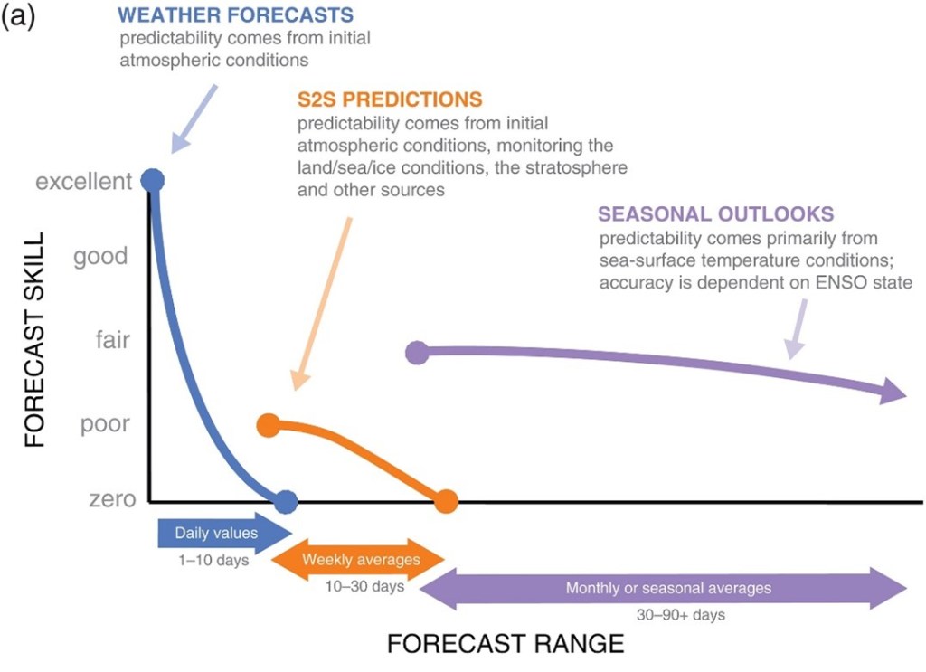
Figure 1: Schematic of medium-range, S2S and seasonal forecasts and their relative skill. [Figure 1 in White et al. (2017)] 

In general, S2S forecasts suffer from relatively low skill. While medium-range forecasts are an initial value problem (depending largely on the initial conditions of the forecast) and seasonal forecasts are a boundary value problem (depending on slowly-varying constraints to the predictions, such as the El Niño-Southern Oscillation), S2S forecasts lie somewhere between the two. However, certain “windows of opportunity” can occur that have the potential to increase S2S skill – and a major SSW is one of them. Skilful S2S forecasts can be of particular benefit to public health planners, the transport sector, and energy demand management, among many others.  

Following an SSW, the eddy-driven jet stream tends to weaken and shift equatorward. This is characteristic of the negative North Atlantic Oscillation (NAO) and negative Arctic Oscillation (AO), and during these patterns the risk of cold air outbreaks significantly increases in places like northwest Europe. So, by knowing this, S2S forecasts issued during the major SSW were able to highlight the increased risk of severely cold weather.  

Given that we know that following an SSW certain weather types are more likely for several weeks, and forecasts may be more skilful, it might seem advantageous to know an SSW was coming at a long lead-time in order to really push the boundaries of S2S prediction. So, what about in 2018?  

In the first paper from my PhD, published in July 2019 in JGR-Atmospheres, we explored the onset of predictions of the February 2018 SSW. We found that, until about 12 days beforehand, extended-range forecasts that contribute to the S2S database (an international collaboration of extended-range forecast data) did not accurately predict the event; in fact, most predictions indicated the vortex would remain unusually strong! 

We diagnosed that anticyclonic wave breaking in the North Atlantic was a crucial synoptic-scale “trigger” event for perturbing the stratospheric vortex, by enhancing vertically propagating Rossby waves (which weaken the vortex when they break in the stratosphere). Forecasts struggled to predict this event far in advance, and thus struggled to predict the SSW. We called the pattern the “Scandinavia-Greenland (S-G) dipole” – characterised by an anticyclone over Scandinavia and a low over Greenland (Figure 2), and we found it was present before 35% of previous SSWs (1979-2018). The result agrees with several previous studies highlighting the role of blocking in the Scandinavia-Urals region, but was the first to suggest such a significant impact of a single tropospheric event.  
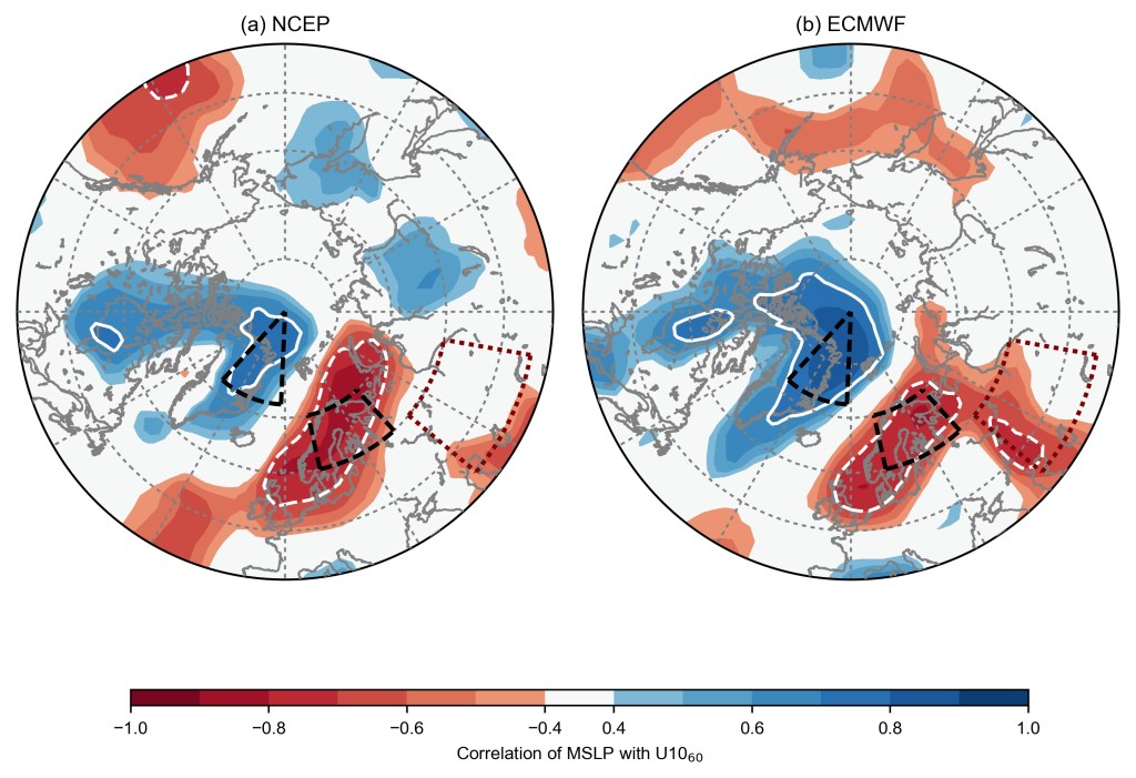
Figure 2: Correlation between mean sea level pressure forecasts over 3-5 February 2018 and subsequent forecasts of 10 hPa 60°N zonal-mean zonal wind on 9-11 February, in (a) NCEP and (b) ECMWF ensembles launched between 29 January and 1 February 2018. White lines (dashed negative) indicate correlations exceeding +/- 0.7, while the black dashed lines indicate the nodes of the S-G dipole. [Figure 3 in Lee et al. (2019)] 

So, we had established the S-G dipole was important in the predictability onset in 2018, and important in previous cases – but how well do S2S models generally capture the pattern?  

That was the subject of our recent (open-access) paper, published in August in QJRMS. We define a more generalised pattern by performing empirical orthogonal function (EOF) analysis on mean sea-level pressure anomalies in a region of the northeast Atlantic during November-March in ERA5 reanalysis (Figure 3).  While the leading EOF (the “zonal pattern”) resembles the NAO, the 2nd EOF resembles the S-G dipole from our previous paper – so we call it the “S-G pattern”.  
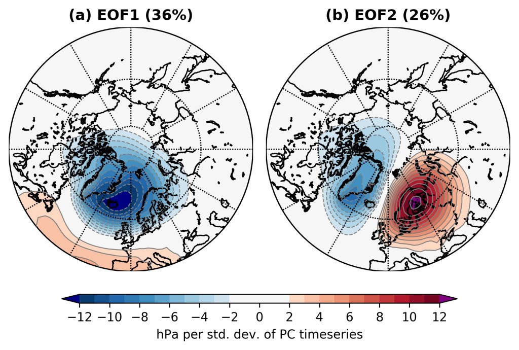
Figure 3: The first two leading EOFs of MSLP anomalies in the northeast Atlantic during November-March in ERA5, expressed as hPa per standard deviation of the principal component timeseries. The percentage of variance explained by the EOF is also shown. [Figure 1 in Lee et al. (2020) 

We then establish, through lagged linear regression analysis, that the S-G pattern is associated with enhanced vertically propagating wave activity (measured by zonal-mean eddy heat flux) into the stratosphere, and a subsequently weakened stratospheric vortex for the next 2 months. Thus, it supports our earlier work, and motivates considering how the pattern is represented in S2S models. To do this, we look at hindcasts – forecasts initialised for dates in the past – from 10 different prediction systems from around the world.  

We find that while all the S2S models represent the spatial pattern of these two EOFs very well, some have biases in the variance explained by the EOFs, particularly at weeks 3 and 4 (Figure 4). Broadly, all the models have more variance explained by their first EOF compared with ERA5, and less by the second EOF – but this bias is particularly large for the three models with the lowest horizontal resolution (BoM, CMA, and HMCR).  
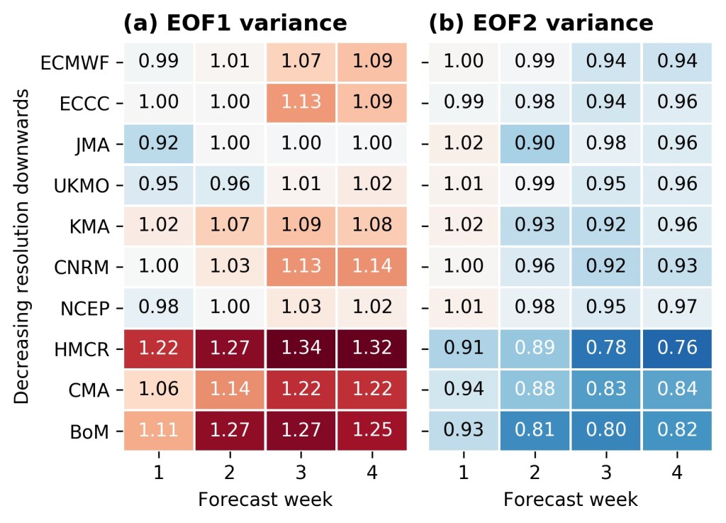
Figure 4: Weekly-mean ratio between the variance explained by the EOFs in each model and the ERA5 EOF. [Figure 6 in Lee et al. (2020)] 

Additionally, we find that the deterministic prediction skill in the S-G pattern (measured by the ensemble-mean correlation) can be as small as 5-6 days for the BoM model – and only as high as 11 days in the higher resolution models. Extending this to probabilistic skill in weeks 3 and 4, we find models have only limited (if any) skill above climatology in weeks 3 and 4 (and much less than the skill in the leading EOF, the NAO-like pattern).  

Furthermore, we find that the relationship between the S-G pattern and the enhanced heat flux in the stratosphere decays with lead-time in most S2S models, even in the higher-resolution models (Figure 5). Thus, this suggests that the dynamical link between the troposphere and stratosphere weakens with lead time in these models – so even a correct tropospheric prediction may not, in these cases, have a subsequently accurate extended-range stratospheric forecast. 
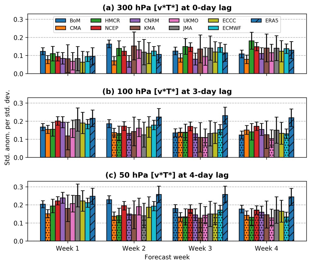
Figure 5: Weekly mean regression coefficients between the S–G index and the corresponding eddy heat flux anomalies at (a) 300 hPa on the same day, (b) 100 hPa three days later, and (c) 50 hPa four days later. The lags correspond to days with maximum correlation in ERA5. Stippled bars indicate a significant difference from ERA5 at the 95% confidence level. [Figure 11 in Lee et al. (2020)] 

So, when taking this all together, we have: 

  • The S-G pattern is the second-leading mode of MSLP variability in the northeast Atlantic during winter. 
  • It is associated with enhanced vertically propagating wave activity into the stratosphere and a weakened polar vortex in the following weeks to months. 
  • S2S models represent the spatial patterns of the two leading EOFs well. 
  • Most S2S models have a zonal variability bias, with relatively more variance explained by the leading EOF and correspondingly less in the second EOF.  
  • This bias is largest in the lowest-resolution models in weeks 3 and 4.  
  • Extended range skill in the S-G pattern is low, and lower than for the NAO-like zonal pattern. 
  • The linear relationship between the S-G pattern and eddy heat flux in the stratosphere decays with lead-time in most S2S models.  

The zonal variance bias is consistent with S2S model biases in Rossby wave breaking and blocking, while these biases have been widely found to be largest in the lowest resolution models. The results suggest that the poor prediction of the S-G event in February 2018 is not unique to that case, but a more generic issue. Overall, the combination of the variability biases, the poor extended-range predictability, and the poor representation of its impact on the stratospheric vortex at longer lead-times likely contributes to limiting skill at predicting major SSWs on S2S timescales – which remains low, despite the stratosphere’s much longer timescales. Correcting the biases outlined here will likely contribute to improving this skill, and subsequently increasing how far we are able to predict real-world weather.   
North American weather regimes and the stratospheric polar vortex

s.h.lee@pgr.reading.ac.uk

The use of weather regimes offers the ability to categorise the large-scale atmospheric circulation pattern over a region on any given day. One way of doing this is through k-means clustering of the 500 hPa geopotential height anomaly field. Cassou (2008) determined the lagged influence of the Madden-Julian Oscillation (MJO) on four wintertime regimes over the North Atlantic; these regimes have subsequently become commonly used (e.g. they are in use operationally at ECMWF). Charlton-Perez et al. (2018) used the same four regimes to describe the influence of the stratospheric polar vortex on Atlantic circulation patterns.

Stratosphere-troposphere coupling is often described in terms of either the annular modes (the leading principal component (PC) of hemisphere-wide variability, often known as the Arctic and Antarctic Oscillations (AO/AAO) when discussing the lower-troposphere) or regional leading principal components (such as the North Atlantic Oscillation (NAO)). However, by their definition, this doesn’t tell the full story – only some percentage of it (around 1/3 for the NAO). The downward coupling of stratospheric circulation anomalies onto tropospheric weather patterns is an area of active research. For example, not every sudden stratospheric warming (SSW) event exhibits the “canonical” response in the troposphere of a strongly negative NAO-type pattern (Karpechko et al. 2017, Domeisen et al. 2020).

Could regimes tell us something more? Specifically – could they shed light onto the impact of the stratosphere on North America, which has been under-explored compared with Europe? In a recent paper (Lee et al. 2019), we look at just that.

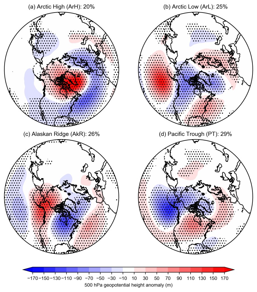
We use 500 hPa geopotential height anomalies in the sector 20-80°N 180-30°W from ERA-Interim reanalysis for December—March 1979—2017. In order to describe only the large-scale variability, we first reduced the dimensionality of the problem by performing the clustering on a filtered dataset – achieved by retaining only the first 12 PCs which explain 80% of the variance in the dataset. We set k a priori to be 4 in the ­k-means clustering, following Vigaud et al. (2018). The number of clusters is somewhat arbitrary, but 4 has been shown to be significant when comparing with a reference noise model (i.e., testing if the clusters are just the result of forcefully clustering noise, or something meaningful). Once the clusters have been determined from analysis of the dataset – the “centroids” – each day in the dataset is assigned to one of the clusters. The patterns produced (Figure 1) are like a similar analysis in Straus et al. (2007) so we adopt their names.

Figure 1: 500 hPa geopotential height anomalies for the four North American weather regimes. Anomalies are expressed with respect to a linearly de-trended 1979-2017 base period. Stippling indicates significance at the 95% confidence level according to a two-sided bootstrap re-sampling test.

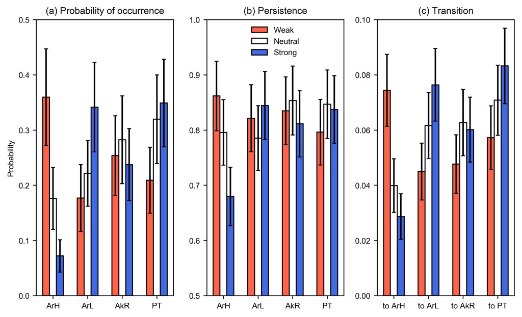
To diagnose how these regimes vary with the state of the stratospheric vortex, we compute some statistics (Figure 2) based on the tercile category of the 100 hPa 60°N zonal-mean zonal wind on the preceding day (“strong”, “neutral”, and “weak”). 100 hPa is used as a lower-stratospheric measure (compared with 10 hPa used for diagnosing major sudden stratospheric warmings) to assess only those anomalies in the stratosphere which have the potential to influence tropospheric weather.

Figure 2: Probabilities of (a) occurrence, (b) persistence, and (c) transition from another regime into each regime stratified by the tercile anomaly categories of 100 hPa 60°N zonal-mean zonal wind. Error bars indicate 95% binomial proportion confidence intervals where the sample size has been scaled to account for lag-1 autocorrelation.

Evidently, the Arctic High regime is strongly sensitive to the strength of the stratospheric winds, being 7 times more likely following a weak vortex versus a strong vortex. The Arctic Low regime displays the opposite sensitivity, being more likely following a strong vortex. A similar but weaker relationship is found for the Pacific Trough. The Alaskan Ridge regime, however, does not display a sensitivity to the vortex strength. This result was somewhat surprising as the Alaskan Ridge regime resembles a pattern which became known as a “polar vortex outbreak”, but we suggest that (a) the similarity of the pattern to the Tropical-Northern Hemisphere pattern may indicate tropospheric forcing exhibits greater control on this regime, and (b) a possible influence through a barotropic anomaly exists from a distortion of the stratospheric vortex (which is not manifest in the zonal-mean zonal wind).

We relate these regimes to impactful real-world weather by computing the probability of an extreme cold temperature (defined as 1.5 standard deviations below normal) in each regime (Figure 3). We find that the greatest likelihood of widespread extreme cold in North America is during the Alaskan Ridge regime, with secondary likelihood of extreme cold for the west coast during the Arctic Low (recall that this pattern is more likely following a strong vortex), and only a low probability during the Arctic High regime (which is strongly associated with extreme cold in Europe).

Figure 3: Proportion of days assigned into each regime over the period 1 January 1979-31 December 2017 (DJFM days only) where normalised temperatures dropped below -1.5 standard deviations. Stippling indicates 95% confidence according to a one-sided bootstrap re-sampling test.

Our results therefore suggest that the strength of the stratospheric polar vortex does not change the likelihood of the circulation pattern with the greatest potential for driving extreme cold weather in North America (in stark contrast to Europe), and that prediction of this pattern should look elsewhere – either to the tropics, or to changes in the shape of the stratospheric vortex – including wave reflection events (Kodera et al. 2008, Kretschmer et al. 2018).

Further work will investigate how well these regimes and their response to changes in the stratosphere are captured by the extended-range forecasting models which comprise the S2S database.

This work was funded by the NERC SCENARIO doctoral training partnership.

Sudden Stratospheric Warming does not always equal Sudden Snow Shoveling

Email: s.h.lee@pgr.reading.ac.uk

During winter, the poles enter permanent darkness (“the polar night”) and undergo strong radiative cooling. In the stratosphere – a dry, stable layer of the atmosphere around 10-50 km above the surface – this cooling is particularly effective. By thermal wind balance, the strong polar cooling leads to the formation of the stratospheric polar vortex (SPV), a planetary scale westerly circulation that sits atop each winter pole (Figure 1).

Figure 1: The Arctic stratospheric polar vortex, here shown at 10 hPa, on March 12, 2019. Geopotential height is contoured, and filled colours show the wind speed in m/s. The zonal-mean zonal wind at 60°N is shown in the bottom left, a commonly used diagnostic of the strength of the SPV. After Figure 6 in Lee and Butler (2019).

In the Northern Hemisphere, the SPV is highly variable, thanks to the generation of large planetary waves in the mid-latitude westerly flow (driven primarily by mountains and land-sea contrast around the continents), which can propagate vertically into the stratosphere and break there, decelerating and deforming the SPV and warming the stratosphere.  In the Antarctic, the presence of the Southern Ocean in the mid-to-high latitudes encircling Antarctica means no similar waves are typically produced. The Antarctic SPV is therefore much stronger than its Arctic counterpart, which is why the ozone hole developed there rather than over the Arctic – with the colder temperatures inside the vortex allowing for the formation of polar stratospheric clouds, which catalyse the reactions that deplete ozone.

Now, since all the weather we experience takes place in the troposphere, you might wonder why we should worry about what happens in the layer above that. In the past, numerical weather prediction models did not resolve the stratosphere, because it wasn’t considered worth the extra computational resources. However, it is now known that the state of the SPV can act as a boundary condition to weather forecasts (especially long-range forecasts that extend beyond 2 weeks ahead, e.g. Scaife et al. (2016)) in a similar way to sea surface temperatures (SSTs). One of the reasons for this is the longer timescales present in the stratosphere (also analogous to SSTs) compared with tropospheric weather systems – an anomaly present in the stratosphere has a long persistence time. But how do these stratospheric anomalies influence the weather we experience?

Let’s take one particularly exciting case of SPV variability: major sudden stratospheric warmings (SSWs). SSWs (defined by the 10 hPa 60°N zonal-mean zonal wind reversing from westerlies to easterlies) occur on average 6 times per decade (Butler et al. 2017) and are associated with either a displacement of the SPV off the Pole, or a split of the SPV into two daughter vortices. Coincident with this is a rapid heating of the polar stratosphere (~50°C in a few days) due to adiabatic warming of descending air – hence the name. The most recent major SSW occurred on 2 January 2019 (Figure 2), but one also occurred on 12 February 2018.

Figure 2: As in Figure 1 but for 2 January 2019 (after Figure 4 in Lee and Butler (2019)).

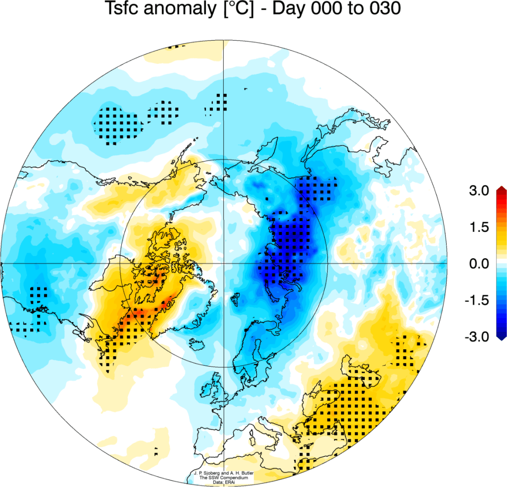
Following a major SSW, the easterly winds descend through the stratosphere over the next few weeks and tend to persist for weeks to months in the lower stratosphere. What happens beneath that in the troposphere is then more varied, but on average there is a transition to a negative Northern Annular Mode (NAM). In a negative NAM, the mid-latitude westerlies associated with the tropospheric jet stream weaken and shift equatorward, increasing the likelihood of cold air outbreaks (and, yes, snow!) in places like the UK and northern Europe (Figure 3). However, that’s only the average response!

Figure 3: Average surface temperature anomaly for days 0-30 following all major SSWs in ERA-Interim 1979-2014. [Source: SSW Compendium]

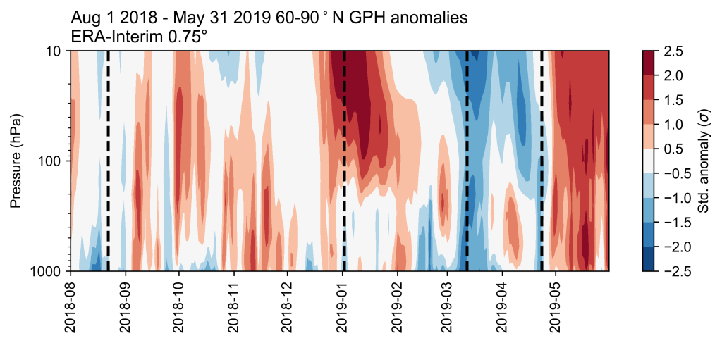
In February-March 2018, we did indeed see this response following a major SSW – immortalised as the ‘Beast from the East’ with record-breaking cold weather and heavy snowfall in the UK (e.g. Greening and Hodgson 2019). But following the January 2019 SSW, there was no similar weather pattern. Figure 4 shows a cross-section of polar cap geopotential height anomalies (analogous to the NAM). Reds effectively indicate weaker westerly winds, and the major SSW is evident in the centre (second dashed line from the left). However, it doesn’t persistently “drip” down into the troposphere below 200 hPa, with only a brief “drip” in early February 2019. For the most part, the stratosphere and troposphere did not “talk” to each other.

Figure 4: 60-90°N geopotential height anomaly time-height cross-section for August 2018-May 2019. Vertical dashed lines indicate (left-right) the SPV spin-up, the major SSW, a strong vortex event (Tripathi et al. 2015), and the vortex dissipation. (After Figure 8 in Lee and Butler (2019).)

This SSW was thus “non-downward propagating” (Karpechko et al. 2017), which is the case with somewhere close to half of the observed events.

Why?

Some research suggests this may be due to the type of SSW (split vs. displacement, e.g. Mitchell et al. 2013), the tropospheric weather regimes present following the SSW (e.g. Charlton-Perez et al. 2018), the evolution of the SSW (e.g. Karpechko et al. 2017), the interaction of the vertically-propagating waves with the SPV at the time of the SSW (e.g. Kodera et al. 2016), or some combination of those. Perhaps other forcing from the troposphere may dominate over the signal from the stratosphere – such as the teleconnection of the Madden-Julian Oscillation (MJO) to the North Atlantic weather regimes (e.g. Cassou 2008).

Thus, whilst an SSW may make cold weather more likely, it’s by no means guaranteed – and we still don’t fully understand the mechanisms involved with downward coupling. That’s one of the reasons why, regardless of what the tabloids may tell you, sudden stratospheric warming does not always guarantee sudden snow shoveling!

References

Butler, A. H., J. P. Sjoberg, D. J. Seidel, and K. H. Rosenlof, 2017: A sudden stratospheric warming compendium. Earth System Science Data, https://doi.org/10.5194/essd-9-63-2017

Cassou, C., 2008: Intraseasonal interaction between the Madden–Julian Oscillation and the North Atlantic Oscillation. Nature, https://doi.org/10.1038/nature07286

Charlton-Perez, A. J., L. Ferranti, and R. W. Lee, 2018: The influence of the stratospheric state on North Atlantic weather regimes. Quarterly Journal of the Royal Meteorological Society, https://doi.org/10.1002/qj.3280

Greening, K., and A. Hodgson, 2019: Atmospheric analysis of the cold late February and early March 2018 over the UK. Weather, https://doi.org/10.1002/wea.3467

Karpechko, A. Yu., P. Hitchcock, D. H. W. Peters, and A. Schneidereit, 2017: Predictability of downward propagation of major sudden stratospheric warmings. Quarterly Journal of the Royal Meteorological Society, https://doi.org/10.1002/qj.3017

Kodera, K., H. Mukougawa, P. Maury, M. Ueda, and C. Claud, 2016: Absorbing and reflecting sudden stratospheric warming events and their relationship with tropospheric circulation. Journal of Geophysical Research: Atmospheres, https://doi.org/10.1002/2015JD023359

Lee, S. H., and A. H. Butler, 2019: The 2018-2019 Arctic stratospheric polar vortex. Weather, https://doi.org/10.1002/wea.3643

Mitchell, D. M., L. J. Gray, J. Antsey, M. P. Baldwin, and A. J. Charlton-Perez, 2013: The Influence of Stratospheric Vortex Displacements and Splits on Surface Climate. Journal of Climate, https://doi.org/10.1175/JCLI-D-12-00030.1

Scaife, A. A., A. Yu. Karpechko, M. P. Baldwin, A. Brookshaw, A. H. Butler, R. Eade, M. Gordon, C. MacLachlan, N. Martin, N. Dunstone, and D. Smith, 2016: Seasonal winter forecasts and the stratosphere. Atmospheric Science Letters, https://doi.org/10.1002/asl.598

Tripathi, O. P, A. Charlton-Perez, M. Sigmond, and F. Vitart, 2015: Enhanced long-range forecast skill in boreal winter following stratospheric strong vortex conditions. Environmental Research Letters, https://doi.org/10.1088/1748-9326/10/10/104007