Email: Jake.J.Gristey@noaa.gov
Web: https://cires.colorado.edu/researcher/jake-j-gristey
Gristey, J.J., J.C. Chiu, R.J. Gurney, K.P. Shine, S. Havemann, J. Thelen, and P.G. Hill, 2019: Shortwave Spectral Radiative Signatures and Their Physical Controls. J. Climate, 32, 4805–4828, https://doi.org/10.1175/JCLI-D-18-0815.1
Sunlight reaching the Earth is comprised of many different colours, or wavelengths. Some of these wavelengths cannot be detected by the human eye, such as the ultraviolet (UV) wavelengths which famously cause sunburn. Fortunately for us, the most intense sunlight is found at harmless visible wavelengths and reaches the surface with relative ease, allowing us to see during the daytime. Sometimes nature aligns to dramatically separate these wavelengths, producing beautiful optical phenomena such as rainbows. More often, however, the properties of the atmosphere and surface lead to intricate differences in the wavelengths of sunlight that get reflected back to space (Fig. 1).

Satellites have observed specific wavelengths of reflected sunlight to infer the properties and evolution of our climate system for decades. Satellites have also independently measured the total amount of reflected sunlight across all wavelengths to track energy flows into and out of the Earth system. It has been less common to make spectrally resolved measurements at many contiguous wavelengths throughout the solar spectrum. In theory, these measurements would simultaneously provide the total energy flow – by integrating over the wavelengths – and the “spectral signature” associated with all atmospheric and surface properties that determined this energy flow. Our recent study puts this theory to the test.
Almost 100,000 spectra of reflected sunlight were computed at the top-of-atmosphere under a diverse variety of conditions. Applying a clustering technique to the computed spectra (which identifies “clusters” in a dataset with similar characteristics) revealed distinct spectral signatures. When we examined the atmospheric and surface properties that were used to compute the spectra belonging to each spectral signature, a remarkable separation of physical properties was found (Fig. 2).

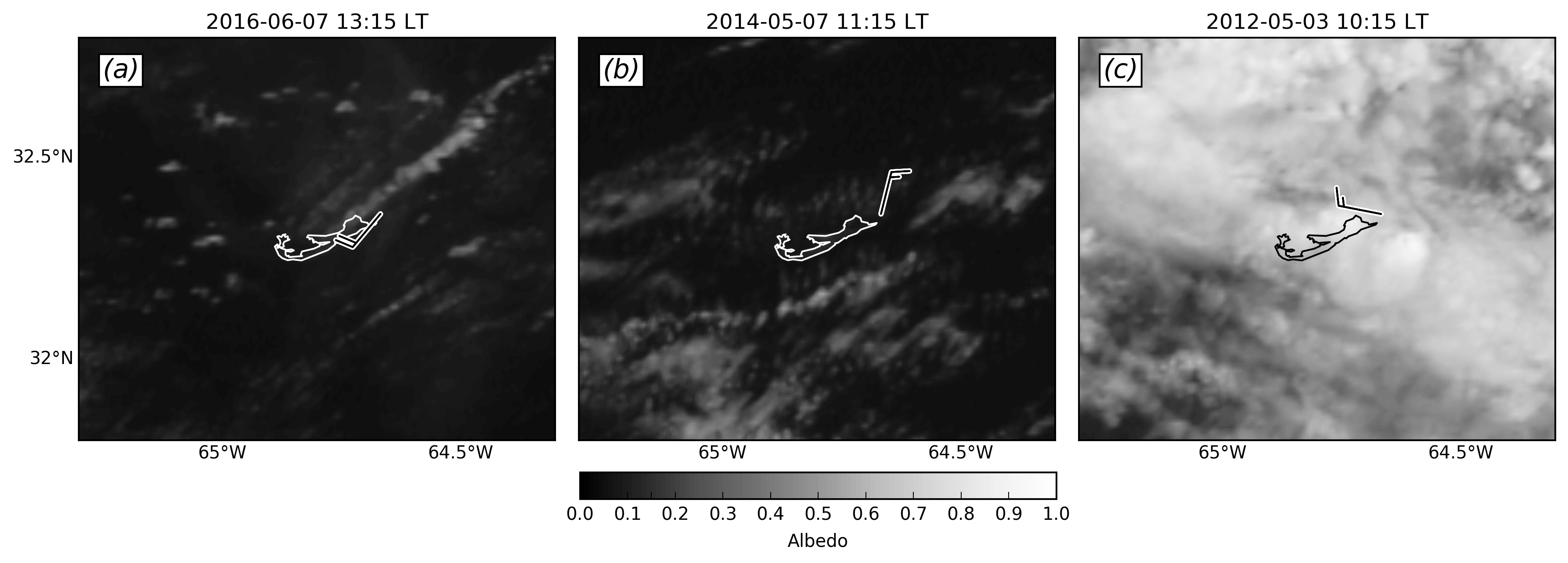
Surprisingly, the separation of physical properties by distinct spectral signatures, as shown in Fig. 2, was found to be robust up to the largest spatial scales tested of 240 km. This is similar to the footprint size of one of the only previous satellite instruments to measure contiguous spectrally resolved reflected sunlight, the SCIAMACHY**, providing an exciting opportunity to investigate spectral signature variability in real observations. We found that the frequency of spectral signatures in real SCIAMACHY observations followed the expected behaviour during the West African monsoon very closely (Fig. 3).

Overall, the separation of physical properties by distinct spectral signatures demonstrates great promise for monitoring evolution of the Earth system directly from spectral reflected sunlight in the future.
Funding acknowledgement: This work was supported by the Natural Environment Research Council (NERC) SCience of the Environment: Natural and Anthropogenic pRocesses, Impacts and Opportunities (SCENARIO) Doctoral Training Partnership (DTP), Grant NE/L002566/ 1, and from the European Union 7th Framework Programme under Grant Agreement 603502 [EU project Dynamics–Aerosol–Chemistry–Cloud Interactions in West Africa (DACCIWA)]
*Note several key simplifications in Fig. 1 for the purposes of visual effect: atmospheric properties are separated, but often occur simultaneously and throughout the atmosphere; the depicted path of sunlight is one option, but sunlight emerging at the top of the atmosphere will come from many different paths; sunlight reflected by the surface will need to travel back through the same gases (and likely other properties) on its way back to the top of the atmosphere, which is not shown. The spectra in Fig. 1 are generated with SBDART using a set of arbitrary but realistic atmospheric and surface properties.
** SCIAMACHY = Scanning Imaging Absorption Spectrometer for Atmospheric Chartography.
Jake completed his PhD at Reading in 2018 and now works at the NOAA Earth System Research Laboratory (ESRL) in Boulder, Colorado.