Email: a.volonte@pgr.reading.ac.uk
It was the morning of 16th October when South East England got battered by the Great Storm of 1987. Extreme winds occurred, with gusts of 70 knots or more recorded continually for three or four consecutive hours and maximum gusts up to 100 knots. The damage was huge across the country with 15 million trees blown down and 18 fatalities.

The forecast issued on the evening of 15th October failed to identify the incoming hazard but forecasters were not to blame as the strongest winds were actually due to a phenomenon that had yet to be discovered at the time: the Sting Jet. A new topic of weather-related research had started: what was the cause of the exceptionally strong winds in the Great Storm?
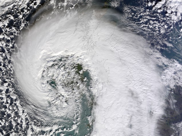
It was in Reading at the beginning of 21st century that scientists came up with the first formal description of those winds, using observations and model simulations. Following the intuitions of Norwegian forecasters they used the term Sting Jet, the ‘sting at the end of the tail’. Using some imagination we can see the resemblance of the bent-back cloud head with a scorpion’s tail: strong winds coming out from its tip and descending towards the surface can then be seen as the poisonous sting at the end of the tail.

In the last decade sting-jet research progressed steadily with observational, modelling and climatological studies confirming that the strong winds can occur relatively often, that they form in intense extratropical cyclones with a particular shape and are caused by an additional airstream that is neither related to the Cold nor to the Warm Conveyor Belt. The key questions are currently focused on the dynamics of Sting Jets: how do they form and accelerate?
Works recently published (and others about to come out, stay tuned!) claim that although the Sting Jet occurs in an area in which fairly strong winds would already be expected given the morphology of the storm, a further mechanism of acceleration is needed to take into account its full strength. In fact, it is the onset of mesoscale instabilities and the occurrence of evaporative cooling on the airstream that enhances its descent and acceleration, generating a focused intense jet (see references for more details). It is thus necessary a synergy between the general dynamics of the storm and the local processes in the cloud head in order to produce what we call the Sting Jet .

References:
Browning, K. A. (2004), The sting at the end of the tail: Damaging winds associated with extratropical cyclones. Q.J.R. Meteorol. Soc., 130: 375–399. doi:10.1256/qj.02.143
Clark, P. A., K. A. Browning, and C. Wang (2005), The sting at the end of the tail: Model diagnostics of fine-scale three-dimensional structure of the cloud head. Q.J.R. Meteorol. Soc., 131: 2263–2292. doi:10.1256/qj.04.36
Martínez-Alvarado, O., L.H. Baker, S.L. Gray, J. Methven, and R.S. Plant (2014), Distinguishing the Cold Conveyor Belt and Sting Jet Airstreams in an Intense Extratropical Cyclone. Mon. Wea. Rev., 142, 2571–2595, doi: 10.1175/MWR-D-13-00348.1.
Hart, N.G., S.L. Gray, and P.A. Clark, 0: Sting-jet windstorms over the North Atlantic: Climatology and contribution to extreme wind risk. J. Climate, 0, doi: 10.1175/JCLI-D-16-0791.1.
Volonté, A., P.A. Clark, S.L. Gray. The role of Mesoscale Instabilities in the Sting-Jet dynamics in Windstorm Tini. Poster presented at European Geosciences Union – General Assembly 2017, Dynamical Meteorology (General session)

2 thoughts on “Sting Jet: the poisonous (and windy) tail of some of the most intense UK storms”